Tbilisi, where a large part of Georgia’s population lives, is naturally characterized by heavy traffic. When cycling in Tbilisi, the primary challenge is safe mobility.
"Safety first" – this principle guided the creation of the map we are discussing. However, the fact that:
- Ramps are not available in all necessary locations
- The surface of sidewalks is poorly maintained and is often used for car parking
- There is a lack of pedestrian crossings and traffic lights
- Areas around ongoing construction sites do not account for pedestrians, forcing them to walk on the roadway instead of the sidewalk
- Underground and overground so-called pedestrian bridges are impractical for cyclists to use
Creates discomfort and, in some cases, danger.
How the Idea Emerged
Let me tell you how the idea of creating this map came about: American Doug Morris, author of several guidebooks about different European cities, visited Tbilisi. He wanted to use a bicycle here, just as he had elsewhere, and faced the reality that those living in Tbilisi know very well.
Afterwards, with the involvement of several experienced cyclists and “Caucasus Cycling Network”, a map was created. With its help, it is possible to travel safely from the westernmost point of Tbilisi – Tbilisi Mall – to the easternmost point, the airport, using sidewalks, bus lanes, bike lanes, and less congested streets. According to Doug, Saturday and Sunday are the best days to ride these routes, as traffic is lighter.
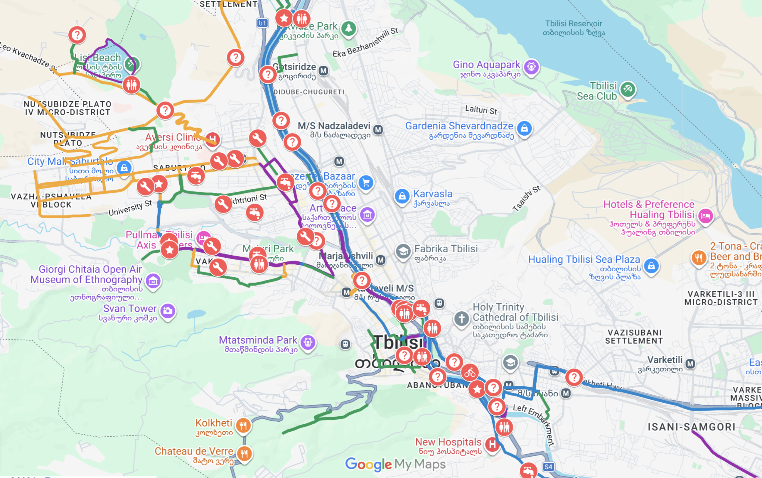
How to Read the Map
In order to use the map, you should know that:
- Purple lines indicate bike paths or bike lanes on streets.
- Blue lines represent sidewalks and imply that cars do not drive there, although reality is slightly different.
- Green lines mark recommended, less busy roads where cycling is relatively safe; they may also indicate bus lanes.
- Yellow lines indicate areas where you should ride with extra caution, as cars move at high speed.
- Red lines mark streets where cycling is dangerous due to heavy traffic.
- Markers with a “?” contain information that may be useful for cyclists crossing that specific location.
- A “star” marks places where minor infrastructure intervention is needed, such as adding a pedestrian crossing, in order to maintain continuity of the cycling network.
- A “bicycle” icon marks locations where fundamental intervention from Tbilisi City Hall is required to create proper cycling infrastructure, which is entirely feasible in those specific areas.
This map also includes everything that may be useful for cyclists, in our opinion: bike workshops, shops, drinking water fountains, public restrooms, and tire repair services.
When you open the map, you will see comments providing as detailed descriptions as possible about specific streets, intersections, or sidewalks. Currently, they are in English, and we will soon add Georgian.
Work on the map is ongoing, and we hope that Tbilisi City Hall will contribute to solving the above-mentioned infrastructure problems. In some cases, only minimal cost and intervention are required to make Tbilisi a more bike-friendly city than it is now.


Comments (0)
No comments yet.